


Learn more about Granite Bay; the Granite Bay Community Association, the Granite Bay Alert, the Granite Bay Community Plan and much more.
Learn more about Granite Bay's history.
The unincorporated Placer County community of Granite Bay had a population of about 20,000 residents at the 2000 census and covers an area of approximately 25 square miles. It is situated on the north shore of Folsom Lake about 25 miles northeast of Sacramento on the eastern edge of the Sacramento Valley at the base of the Sierra foothills.
The community boasts of a very high quality of life due to its great location, sound community plan, first rate schools, numerous churches, a low crime rate and excellent recreation opportunities. The community is home to some of the Sacramento areas finest and most exclusive homes.
Typically, summers are hot and dry, while winters are cool and rainy. Summers average high temperatures are about 95 degrees but with the usual cooling evening breezes average summer lows drop to about 60 degrees. Average temperatures in the winter range from highs of about 54 to lows near 40 degrees with an occasional frost. Annual rainfall averages near 25 inches per season, falling predominantly in the winter months.
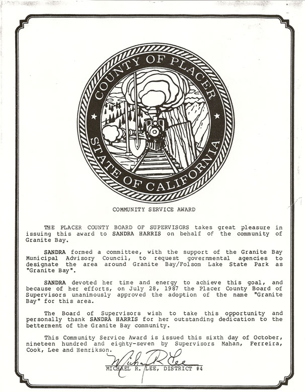
The community was officially recognized as "Granite Bay" in 1987. As an unincorporated community, the Placer County Board of Supervisors is the local governing body, and a local Municipal Advisory Council provides input and advice to the Supervisors.
Granite Bay's roots lead back to the early 1850's, when gold miners first settled the banks of the American River. According to retired Park Ranger Dave McGrath there were 37 gold mining settlements along both sides of the River.
In its earliest beginnings, it was known as "Granite Bar", a small mining camp just below Horseshoe Bar. The North Fork Ditch, built by the Natoma Company between 1852 and 1954, not only allowed miners to surface mine gold, it continued to supply water to the area and attracted settlers who planted olive and almond orchards. When the lake is low you can still find rows of stumps straight out from the Granite Bay boat launch ramp. Remains of the ditch can still be seen in places along the trail leading up the lake from Horseshoe Bar and along the water's edge above the dam at low lake level. The sides of the ditch were concreted in 1925, which has helped to preserve its visibility.
Vivian Rasmussen recalled that what was is now called Auburn-Folsom Road was originally called Auburn-Sacramento Road. The road was built in 1850 to allow miners to travel back and forth with supplies. Whiskey Bar, Horseshoe Bar, and Rattlesnake Bar Roads were all established to connect the various settlements to the bar or to the main road. Granite Bar, later to be known as Granite Bay was named for the granite rock quarried from its banks and used as rip-rap in the wing dams of Folsom Dam.
Cattle ranchers also took advantage of availability of water and grassy slopes. "There were two major cattle ranges when I moved here in 1956" stated H.T.Newberry, a resident of Skyway. Mooney was one and Grant Bender was the other. "A big chunk of their property was condemned by the government so they could fill the lake" he explained. The remainder of the ranches were subdivided and sold off to people moving into the area.
Granite Bay Vista, an early subdivision by John Mercurio and Louis Gavino, probably helped make the name popular according to Niel Lester, who built a home in the tract with her husband in 1962. Things have changed, naturally said Lester. Douglas Blvd. used to be called Rocky Ridge Road east of Sunrise Blvd.. For most newcomers, Rocky Ridge has no significance since most of the ridge has been demolished with the widening and development along Douglas Blvd. Granite Bay didn't become the official name of the area until July 28, 1987. Until then the expanding housing developments along this section of the lake were just as apt to be referred to as Folsom Lake and were included in Roseville's sphere of influence out to Barton Road for Government Planning purposes.
Residents of the area felt the goal and lifestyle2 of Roseville was not consistent with their own and placed the proposition before the County Board of Supervisors to be recognized as the unincorporated community of Granite Bay. Then Assemblyman, Tim Leslie, issued a proclamentation and with County Supervisor's approval the community became officially known as Granite Bay.
Roseville sphere of influence has subsequently been withdrawn to Sierra College Blvd.
Auburn-Folsom Road has a long and unique history. Starting out as little more than ox-cart tracks linking 49'er mining claims along the American River in the 1800s, it served as a supply line between Auburn and Folsom. It also served to enrich the pockets of bandits laying in wait to relieve travelers of their belongings. The most brazen and famous robber along the stretch was known as "Rattlesnake Dick". Nicknamed not so much for being sneaky, but for the fact that he had once been an honest gold miner at Rattlesnake Bar before turning outlaw and plying his trade along the Auburn-Folsom trail. Later, a spur of the Central Pacific Railroad paralleled the road, connecting Auburn to Folsom in 1862. The Spur was discontinued a few years later. When the railroad workers began to pull up the rails, locals were so incensed shooting broke out at the corner of what is now Moss Lane and Auburn-Folsom Rd.
Before it was Granite Bay, it was called Allen's District. Named after Hiram B. Allen, whose family was one of the families that lived in the area along with the Cavitt's and the Stallman's in the 1800's. The Cavitts lived at the west end of the road and the Stallmans lived at the east end, and that road is known today as Cavitt Stallman Rd. Today, Shelborne Estates occupies part of the old 420 acre Allen ranch. Plum, peach, and pear orchards were the agricultural mainstays. Olives were a major crop at the ranch on the road now known as Olive Ranch Rd. and remnants of the olive trees are today still prominent north of Douglas Blvd. Allen's District featured one of the first real estate ventures in the area called the Rosedale Colony, where land was selling for $50 an acre.
I have lived in Lakeland off Douglas since 1962. Douglas was a 2 lane road and it was known as Rocky Ridge Road. Our mail was delivered from the Roseville Post Office and our zip code was 95678. There were no super markets. There was a small grocery and bait shop located next to where the boat marina is on Douglas east of Auburn-Folsom road. Whispering Pines restaurant was here on Auburn-Folsom road at that time and later there was the Bull Pit restaurant on Douglas where NAPA is now. A liquor store was next door. Later there was 7-Eleven in the same complex as well as a beauty salon, barber shop, and Laundromat. Now all gone.